Find Out Where Centaurs Were
using Google Mapping products.
by Carl Betsill see also Interactive Map of Centaur Events/Places
also Specific Map Locations, and Map Accuracy - Download CentaurPlaces.kmz
Google Earth and Google Earth Pro are free geospatial software applications that display a virtual globe of the Earth. They offer the ability to analyze and capture geographical data. Click here to see a video of how it works. You may be surprised how easy it is.
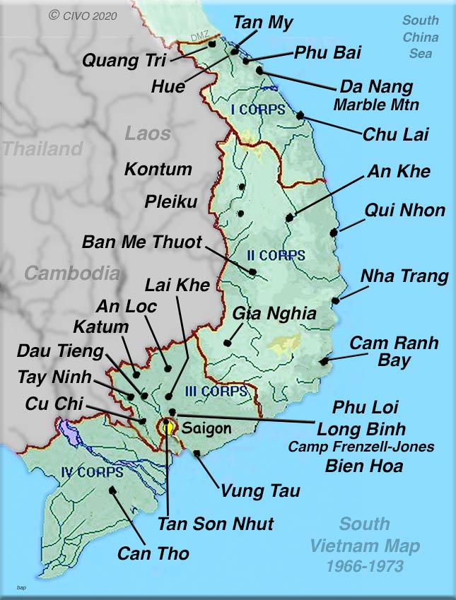 Google Earth Pro, for computers and Google Earth and Google Maps for tablets and phones can all locate current areas in Vietnam. You will probably want to activate “satellite view” if using Maps. The most obvious locations, for example major towns like Tay Ninh and larger air bases like Tan Son Nhut, can be easily found by just entering the name in the search bar. More remote areas are difficult to locate and require looking at Vietnam era military maps and translating the coordinates into something your mapping application can read. This varies depending on the application.
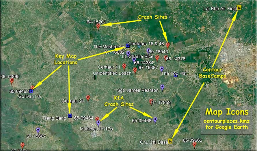
To make things simple we have located many features of interest to the Centaurs and placed them on a Map Locations page. It provides decimal coordinates that will work in any of the three Google mapping products and also allows you to simply find the coresponding 1:50,000 topographic map from the Vietnam era.
To use these just type in the decimal degree coordinates provided on the Map Locations page, even simpler, just copy and paste the coordinates into your Google mapping product's search bar. The program will then take you to the proper location and give you a view of what that areas looks like today. Remember, things look a lot different today than they did 50 years ago. If you have an area you would like to find and can’t locate, let us know.
Click here to go to the Map Locations page.
If you want to locate a Topo Map yourself (old) that is not on our Map Location page click here.
Map Accuracy
When actual feature can be identified on Google Earth, the MGRS (Military Grid Reference System) coordinates may differ from what is shown on the topo maps. This may be errors in the original topo maps or inexact conversion between map projections and differing coordiante systems. When no identifying feature can be distinguished on Google Earth the exact MGRS coordinates are used to locate the area on Google Earth. This usually is within a kilometer of the actual site. For example Camp Evans runway is clearly visible on Google Earth and is even confirmed with a Vietnam era picture marking the spot. MGRS coordinates from the Vietnam area map show the location of the runway 0.66 Km at 134 degrees from the actual site. For a refresher in the use of the Military Grid Reference System click here MGRS.
Google Earth Pro Centaur Interactive Map
"Centaur Places" see update in the October 2023 Newsletter
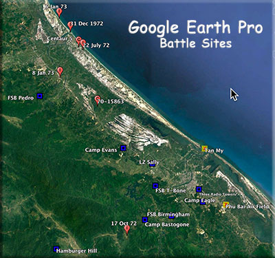 Carl Betsill (Centaur Map Master), along with Mike Peake (Centaur Historian) and Stretch Harrison, put together a fun and informative, Google Earth interactive map for Centaur events. You need to check it out.
Instructions:
1. If you don’t have Google Earth Pro then download it first. It is totally free. There are versions for Mac, PC and Linux. If you have trouble finding and downloading it, just grab any teenager and have them do it.
2. With Google Earth Pro already loaded onto your computer (not opened) then click on this special file that will open Google Earth Pro and display the Centaur map data.... CentaurPlaces.kmz
3. The next alert box will say something like "Open in Google Earth Pro". Click OK.
4. Google Earth will frequently ask you to "Allow" them to save. Just click "Deny" until you are more familiar with the program.
5. Once Google Earth opens and shows you the planet, use your mouse scrolling button to zoom in on the little orange balloon looking markers. You can also press and hold your mouse to move the map around. There are many other controls and features that you can play with later.
6. Click on little orange balloon looking markers for information. In some cases, within that information block, is a link to more info on the Centaur website. Click on the Centaur 5 balloon as an example. It will take you to that page on the Centaur Website but will remain in the Google Earth program. Click the return to Google Earth button usually in the upper left corner of the screen.
You can help us by providing specific information that you have on crash or incident sites.
contact "Betsill, Carl" <betsill@coastalnet.com>